Saturday 27 February 2016

Sugar Loaf Woodlands Special Area of Conservation

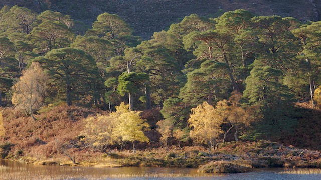
The wind finally dropped, even so the weather was not very inspiring for the hills, with extensive hill fog forecast, so a visit made to an upland wood that I hadn't visited since 2014. The wood is part of the 2,136 acres of the Sugar Loaf Mountain Common, donated to the National Trust in 1936 by Sybil Margaret Thomas, Viscountess Rhondda.  The wood is also one of 4 unit areas that comprise the Natura 2000 site, the Sugar Loaf Woodlands. A Special Area of Conservation (SAC) and Site of Special Scientific Interest (SSSI).

Oak Moss (Evernia prunastri) 
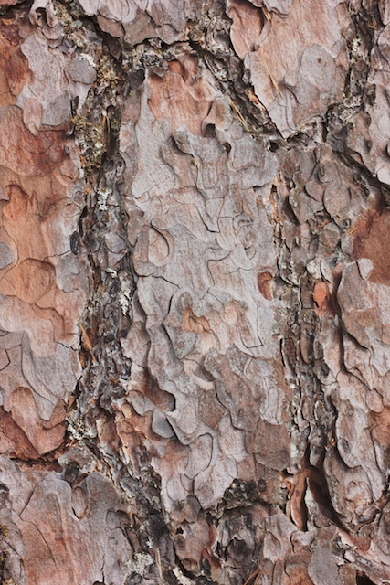
As with most woods the origin and history of the oakwood can only be speculated at; its name Deri, is Welsh for Oak; the nearby town of Abergavenny has an ancient association with iron working and leather tanning, industries that required charcoal and oak bark. There are also a number of charcoal platforms of varying floor/platform area. Many of the oaks show signs of coppicing and high coppice/low pollarding. The earliest Ordnance Survey 6" to the mile map show the wood extent similar to the present woodland. Some sessile oak trees have the look and character of veteran trees, with some possibly of ancient tree status. Woodland tends to pose many questions but few definitive answers.

A sessile oak that appears of some age with regenerating woodland as a backdrop.
A closer look
I thought there would have been some evidence in the more exposed aspects of the wood of storm damage, surprisingly aside from some windblown deadwood and twigs, there was only a cleft bough as testament to winter 2015/16 storms.

A wind blown bough


On the gentler slopes wind had scoured the woodland floor revealing patterned ground, with alternating curvilinear bands of moss and leaf litter in some areas of the wood, the attentions of a mole revealed clean soil with no stone fragments. As the features appear natural and not the result of any agricultural activity I am aware of,  I would hazard a guess at solifluction or hill creep as the process. In other parts of the wood there are lobes of stone, that hint at a more extreme climate in the past.

Molehills and patterned ground


The steepness of the hill slope encourages natural layering of branches for oaks in more open aspects of the woodland.

Natural branch layering

Even in winter it is an interesting woodland to wander around.

Trees with character


As of 15th February 2008 the wood has a core management plan after the Conservation Status Condition of this wood was assessed as Unfavourable (2007), due to:
• Grazing having a strong role in preventing some of the canopy regeneration and in creating a sparser ground flora; 
• Some areas within the SAC/SSSI remain as open areas, especially on the fringe of the site. Whilst having some open areas is beneficial for a range of species, not all these open areas are of benefit to either the SAC or SSSI features; 
• The even-aged and dense canopy in much of the wooded area. This is creating very densely shaded ground, field and shrub layers and is one of the barriers to regeneration of saplings and ground flora. However, more canopy gaps would be expected in the long term as the canopy trees die, or through storm damage in the more exposed parts of the site; Canopy regeneration is a key attribute for signifying the functioning, habitat quality and sustainability of most woodland types, including sessile oak woods. The grazing within all 4 units has suppressed the regeneration of native woody species and in combination with past coppicing has resulted in a uniform age structure. The areas of Sugarloaf woodlands not subjected to continuous grazing, appear to become densely populated with saplings of all species. This may demonstrate that the main factor restricting natural regeneration of woody species in Sugar Loaf Woodlands is grazing and that current grazing levels are incompatible with sustainable semi-natural woodland at this site. The conservation objectives state that the canopy should be composed of locally native trees and, apart from a beech woodland area within Unit 1, the canopy of Sugar Loaf Woodlands is currently dominated by oak throughout. Where beech is present its seedlings tend dominate the regeneration and without management to control these locally non-native seedlings, this will further cause parts of the SAC feature to fail.
From the Action Plan : Summary of Conservation Measures
All of unit is on Sugar Loaf Common and therefore open to grazing, restricting canopy regeneration and extent and luxuriance of ground flora, very difficult to achieve "correct" grazing levels with current tools available. 
I can find no further updates or reports subsequent to the 2008 report.

A Special Area of Conservation has legal protection to ensure that habitat is maintained in a favourable condition. However, the woodland falls within an area of common land, that allows registered members of the Sugarloaf Commoners Association (SCA) to graze animals on the Sugar Loaf Mountain common. A record exists in the Commons Register of a Commons Commissioner Decision dated 1988 "In the matter of Sugar Loaf Mountain Common, Llantillo Pertholey and Llanfoist Fawr Communities and Abergavenny Town, Monmouth District, Gwent." Relating to registrations disputes made under the Commons Registration Act 1965. The following is a screen shot copied from the document.

The Commons Commissioner report raises a few questions not addressed in the hearing, notably the Sugarloaf Commoners Association enthusiasm in 1988 to inflate the numbers of registered grazing sheep from an already unsustainable number of ~15,000 to 18,643, grazing 2,136 acres of land. The Commoners Association were notified by a letter produced in evidence that the woodland was registered as a Site of Scientific Interest (SSSI) in 1985. Judging by a sampling of Decision reports in Commons Registers, the Commons Commissioner was unusually active in the 1980's ruling on Commons Registration disputes, noting the area of Common Land and the surprising numbers of livestock registered under Common grazing rights.

I am uncertain how much common land there is in Europe, but in Wales 8.4% of land is registered common or 175,000 Hectares and in England 3% of land is registered common or 370,000 Hectares.
The New Naturalist book 'The Common Lands of England and Wales' provides an insight into the history and rights associated with common land. The origin of common land is unknown with some suggestions of common land originating in Roman, Iron age, Bronze age or in the Neolithic. The rights of commoners to common land is complex and has even proved challenging to the authority of reigning Monarchs imposing their will.

In June 2006 The State of Common Land in Wales - an indicative study was issued by RSPB Cymru. The following extracts are from the Report Executive Summary
Reform of the management of common land in England and Wales is currently being considered in Westminster and new legislation is expected to follow. Reform has been driven primarily by (i) the need to secure attainment of the UK Government’s target to have over 95% of SSSIs by area in England in favourable condition by 2010 and (ii) the wish to facilitate entry by commoners into agri-environment schemes, and so help secure the sustainable agriculture management of common land in general. 
Various reports in the last fifteen years have set out the need for improved management and protection of our common land; however, there are few current data available to give a clear view of the condition of commons in Wales. This report is an attempt to collate sources on common land in Wales and to assess the state of a small number of commons in Wales. These commons are not a representative sample of commons in Wales; rather, they are presented as a series of illustrative case studies. We also draw some conclusions for the implementation of the new legislation in Wales. 
The report provided an insight into the correlation between common land and protected habitats
45% (79,000 ha) of common land is designated as SSSI
There are 57 SSSIs in Wales that are wholly or mostly (80% - 100% by area) on common land344 commons in Wales that are 80% - 100% by area SSSIs
From information available on 38 of the 57 SSSI's that were wholly or mostly (80% - 100% by area) on common land the following was reported :
  • 71 Species Features of the SSSI - 1 was in a Favourable Condition, 3 were in Unfavourable Condition and 67 were in an Unknown Condition
  • 85 Habitat Features of the SSSI - 17 were in a Favourable Condition, 39 were in Unfavourable Condition and 29 were in an Unknown Condition
In 2006 UK Legislation was introduced in the form of the Commons Act 2006. The Welsh Government implementation of the 2006 Commons Act appears to be progressing at a pace commensurate with the scale and complexity of Common Land in Wales and in 2012 issued some guidance on frequently asked questions of Section 46 Unauthorised Agricultural Activities. There are also incentives in place for commoners to manage the land to ensure favourable conservation status of SAC/SSSI features and it now remains to be seen if the Unfavourable Condition of Sugar Loaf Woodlands SAC woods improves to a Favourable Condition.


Thursday 18 February 2016

The challenges of landscape photography in an Oceanic climate

The Mountain Forecast  provides an excellent insight into the weather of the world's mountains and it makes for some interesting comparisons.

Grand Casse is in the Graian Alps and at 3,852m is the highest summit in the Vanoise massif and in a Humid Continental climate.

 3852m from www.mountain-forecast.com

and lower down
1000m from www.mountain-forecast.com
Store Lenangstind, 1624m is a mountain in the Lyngen Alps, Troms, Norway and subject to a subarctic / subpolar oceanic climate.

1624m from www.mountain-forecast.com


0m from www.mountain-forecast.com


Now a look at the forecast for Ben More Assynt, in the NW Highlands of Scotland at just under a 1000m in height at the summit and in an Oceanic climate

998m from www.mountain-forecast.com

At 0m

 0m from www.mountain-forecast.com


With a weather forecast for the UK it really does pay to consult as many forecasts as possible, if everyone is singing from the same songsheet there's a good probability of increased accuracy


The Met Office Mountain Weather Forecast makes equally grim reading

Met Office Mountain Weather Forecast


and the detail

Met Office Mountain Weather Forecast


If the weather forecast for the summit of Grande Casse appeared on a UK Mountain Weather Forecast, there would be a lot of outdoor enthusiasts planning trips, albeit packing extra warm clothing, the weather forecast for Store Lenangstind, not so good and Ben More Assynt not unusual, it doesn't even rate having a storm name and it is worth noting that the highest forecast winds at 3852m on Grand Casse are less than the forecast sea level winds for the NW Highlands of Scotland.  I'll concede that the the wind chill temperatures forecast for Grand Casse are pretty grim, but note the forecast wind chill on Ben More Assynt, 2,864m lower than Grand Casse and with rain in the forecast too. The windchill at sea level in the NW Highlands is similar to the windchill at sea level inside the Arctic Circle and a reason why UK Coroner's verdicts of death by fatal hypothermia are issued for ill fated outdoor enthusiasts. Even at lower elevations the winds in the UK have a severely limiting effect on what can be photographed.


Rolling the Weather Dice in an Oceanic climate

The UK is affected by the following air streams, that in addition to the vigour of the Jet Stream, will have a profound influence on what the landscape photographer will attempt to photograph.
  1. Polar Maritime 
  2. Returning Polar Maritime
  3. Arctic Maritime 
  4. Polar Continental
  5. Tropical Continental
  6. Tropical Maritime 
The weather dice are loaded though and a betting shop would offer a spread of odds on an air stream at certain times of the year and that's where climate maps are a useful source of info in planning a landscape photography trip. The climate maps produced by the Met Office provide a visual indication of the UK's climate and breakdowns are available by season, month and year.

source http://www.metoffice.gov.uk/public/weather/climate/


source http://www.metoffice.gov.uk/public/weather/climate/


source http://www.metoffice.gov.uk/public/weather/climate/

Add caption

I'll post a future article with some thoughts on how to mitigate some of the challenges posed by an Oceanic climate. It also makes for an interesting analysis of the enthusiasms and appetite of the UK's landscape photography community, when climate, road atlases and topographic maps of the UK are compared with portfolios and galleries.

Monday 15 February 2016

The mission creep of Mountain Rescue Teams

Thankfully I have never had to trouble the Emergency Services and call out a Mountain Rescue Team (MRT) for assistance. The few MRT members I have met, have all been volunteers and most if not all will concede how easy it is to be in the wrong place at the wrong time whilst out climbing or walking in the hills. There are fine margins for error in some hill environments, that can have serious consequences and probably, very few individuals who can say that they haven't experienced a near miss whilst out in the hills at some point. I have great respect for MRT's and their attitude in undertaking what is at times; dangerous, challenging and frustrating rescues.

The online magazine that I read for outdoor news is Grough and it is noticeable that in recent years the coverage has highlighted the mission creep of Mountain Rescue Teams activities, which reads more like Search and Rescue.

cyclistpet dogkayaker,  feckless off road motoristsflooding and feckless off road motorcyclists.

Which contributed to record years in 2015 for some MRT's e.g ConistonKendal and the nature of call outs illustrated by the Brecon MRT. The problem is that their skills are transferrable from the hill environments to other areas. I'll emphasise the point again, these are all volunteers.

From mid 2015 to 2017 the duties of Royal Air Force SAR helicopter services were handed over to a private company. When the UK Government announced the plans to privatise the SAR helicopter service, there were genuine concerns raised from MRT members, that commercial helicopter pilots might not be as enthusiastic or have a similar appetite for adventure as their RAF predecessors and Mountain Rescue Team volunteers would be faced with more time consuming rescues evacuating the injured from difficult terrain in challenging weather conditions and placing additional strain on already stretched resources.

The Statistics presented at the Scottish Mountain Rescue meeting in March 2015 give a breakdown of call incidents and hours of Mountaineering and non-Mountaineering incidents It appears that strain is beginning to tell as in early February 3 Scottish Mountain Rescue Teams were reported as considering leaving the umbrella organisation Scottish Mountain Rescue.  I can't say I blame them.

Monday 8 February 2016

Native Pinewoods of Scotland

I was conducting some research into native pinewoods in Scotland and this post is a summary of the information on native pinewoods.  The distribution of native Scots pinewoods is illustrated on the Joint Nature Conservation Committee website, elsewhere the Forestry Commission maintain a Native Pinewood Inventory of sites.


Distribution of Caledonian Forest
http://jncc.defra.gov.uk/publications/JNCC312/habitat_comparison.asp?FeatureIntCode=H91C0 


The conservation numbers are as follows
  • 84 locations are currently attributed as sites of native pinewoods.
  • 10 of the most notable areas with native pinewoods have been designated as Special Areas of Conservation (SAC), 
  • The remainder mostly designated as Sites of Special Scientific Interest (SSSI)
  • An inventory of Caledonian Pinewoods has been drawn up by the Forestry Commission and the inventory contains all the known pinewoods with more than 30 individual trees where the balance of probability is that they are genuinely native (semi-natural), that is, descended from one generation to another by natural seeding.
  • In 1998 the inventory stated that there was a Pinewood (core) area 17,882 ha, Regeneration zone 25,399 ha and Buffer zone 92032 ha.
  • For a Pinewood to be accepted as a registered source of native scots pine seed it needs to be isolated from pine of non-local origins, normally at least 400 m.
Ballochbuie Forest SAC, 2014

Information that relates to the native pinewoods of Scotland

Early observations
  • Stephens and Carlisle record in their 1959 publication Native Woods Pinewoods of Scotland that there was some controversy and speculation about the quality of native Scots Pine in the 18th C. Timber merchants and tree growers were adamant that there were two distinct species of Scots Pines producing vastly different timber quality. Others disputed that there wasn't two species and instead observed that climate and site determined the quality. Another point of view was that the Scots Pine needed time to mature before being assessed for timber quality and that 30 year plantations were not a reliable guide to mature tree timber quality. Another view was that some planting had been undertaken with 'superior' continental pine seeds, mixed in native seeds. And someone else pointed out that native Scots Pines in the highlands, do not grown in regimented plantations, but in exposed locations upon ground unfit for anything else and when mature demonstrably produce high quality timber.
  • With the issue of timber quality highlighted, there then ensued a concentrated effort starting in the late 18th C to  determine every conceivable physical characteristic of Scotland's Scots Pines; morphology, cone size and shape, seed weight, seed colour, bark character, needle length ...
  • Scots Pines were also characterised from Switzerland, Sweden, Finland, France, Germany and Scotland. Numerous species/varieties of Pinus Sylvestris were proposed/named based on morphology, habit, bark or combinations thereof.
  • Bark studies showed distinct varieties on trees with numerous designations of ridge, mussel, flake, plate and intermediaries. Someone inconveniently pointed out that the character of bark also changes over the course of a tree's lifespan ... Nonetheless, in Scotland's native pinewoods there appeared to be a regional flavour of bark characters.
  • 18th and 19th Century plantings of known continental provenanced Scots pines in Scotland proved disappointing. The ferocity of a 'heelan hooley' was too much for some plantations and the combination of exposure to rain/wind/hail/freeze thaw conditions, affliction from disease/pests produced inferior sub optimal growth in continental trees.
Plate and flake bark, Glen Affric ~ 2013
  • Forestry Commission provenance trials 1929 - 1942 indicated that Scots Pine from continental Europe were superior to Scottish provenanced Scots Pines in southern England and were inferior in Scottish trial locations. Southern England has more of a continental climate, Scotland has an oceanic climate. There was no record on the soil/bedrock geology of the trial sites.
  • When researchers and conservationist arrived at the new Nature Conservancy Council purchased Beinn Eighe National Nature Reserve (NNR) during the 1950's they commented on the differences between the west coast pines and the Highland/Cairngorms pines.
  • Limited trials at an exposed site Glen Trool in 1965 determined that Scots Pines from Loch Maree coped better with Winter Blast than other trees.
Coulin native pinewood, Glen Torridon ~ 2012

Genetic diversity and consequences
  • In the late 20th and early 21st Century genetic research has indicated that the Native Scots Pines are genetically diverse from the European Scots Pine populations and there is also a regional genetic diversity amongst the native pinewoods of Scotland.
  • The genetic diversity continues down at the local level in Wester Ross, with the West Coulin pines being distinct from the East Coulin pines and Loch Maree pines, despite being less than 2 and 4 miles away respectively. 
  • Beinn Eighe National Nature Reserve (NNR) started a tree nursery in the 1953 from seed collected in the reserve, to grow seedlings that would regenerate the native pinewoods on the reserve.
  • In the 1970 the Beinn Eighe NNR closed its tree nursery and the Forestry Commission supplied the Beinn Eighe National Nature Reserve with seed instead from its Black Isle nursery.
  • A shortage of seedlings from the nursery meant the Forestry Commission supplied Glen Affric originated Scots Pine seedlings to the Beinn Ejghe NNR, which were planted.
  • When the genetic studies of the native pinewoods were made available, the Beinn Eighe NNR had to remove Glen Affric sourced Scots Pines to preserve the genetic diversity of the Coulin Pinewoods and also remove Glen Affric sourced Scots Pines plantations adjacent to Coille na Glas Leitire to preserve the genetic diversity of Loch Maree pines.
  • In 1987 Beinn Eighe NNR restarted a tree nursery growing its own local origin seedlings. 
Glen Affric ~ 2013

Dates and pinewood dynamics
  • The oldest living native Scots pine trees date from the 1450's AD in Glen Loyne and Glen Derry.
  • Palynologists declared Scots Pine colonised Scotland around 8,000 years before present from the north west and slowly spread south.
  • Sub fossil Scots Pine retrieved from lochs in the Cairngorms have been dated to just before 8,000 years before present.
  • Dendrochronologists are cautiously optimistic of eventually establishing a sequence of 8,000 years of tree ring chronology data for the Highlands of Scotland from subfossil pine material retrieved from lochs and peat.
  • The East end of Glen Affric has seen a continuous presence of Scots Pine woodland for the last 8,000 years, whilst the West end of Glen Affric has an entirely different history of Scots Pine woodland with very little Scots Pine woodland for the last 4,000 years. Ecologists speculate that the difference is due to a shifting ecotone due to the steep climatic gradient down the glen or blanket peat and hydrology or a combination of both.
  • Historical research has identified a small number of Pinewoods that are recorded in the 17th and 18th Centuries but have either disappeared or are are no longer considered as viable woodland. Some of those pinewoods were already in decline at the time of recording.
  • There is a general consensus that the decline of native pinewoods are a combination of mismanagement and climate.
  • Palynology studies have been suspect in identifying the physical presence of Scots Pines at sites.
  • Climate change is believed to have influenced the ability of Scots Pine to colonise and regenerate on blanket peat.
Screenshot from Forestry Commission